After our too-brief visit to Haines, it was time to head back into the interior of the continent. We took what is called the Haines Hwy from Haines, Alaska to Haines Junction, Yukon (Canada) and from there, the famous Al-Can Hwy to Alaska, a journey of about a week. The scenery was breathtaking and thanks to the book “Milepost” that we follow as we go, the people we meet, and the very informative road signs/placards that we encountered along the way, we learned much about the native people, history, geology, and geography of this area.
 |
| Lily riding north along the Haines Hwy |
 |
| Lake Kathleen |
 |
| Fireweed adds beautiful color to many scenes |
 |
| Land of little trees, "taiga" in Russian |
 |
| Quonset churches not uncommon |
 |
| Lunch stop on Kluane Lake |
 |
| "Diesel" takes a pee in a scenic spot |
 |
| Peggy swims--briefly--in cold Yukon lake |
 |
| Kluane Lake from campground |
 |
| Kluane Lake in repose |
 |
| Woman at visitor's center regaled us with stories of her own gold mining successes in Yukon |
 |
| Back in the USA again |
 |
| Believe it or not, a 20 foot wide swath is periodically mowed through the forest at the international boundary between Alaska and Canada along the 141st meridian all the way from the Arctic Ocean to Mount St. Elias on the Pacific coast! |
The Haines Highway closely follows a trail used by the Southern Tuchone people for many thousands of years in trading with the Chilkat Tlingits of the coast. The Southern Tuchone were our first contact with a totally different tribe, the Athabascans. Athabascans are culturally very different from Tlingits and other coastal native peoples about which I have written much in previous blog postings, and they are no less fascinating and admirable a people. They live in the interior of the continent—Alaska and Yukon—rather than on the coast. As such, they deal with extremes of temperature, from minus 60 degrees F in winter, to 100 degrees F in summer. They live in areas of dryness rather than rainforest. They paddle birchbark canoes on rivers, rather than spruce dugouts on the ocean, and use dogs not only to pull sleds in winter, but as pack animals on their journeys overland in other seasons, and they traveled extensively in search of food, according to the seasons. They hunted all manner of large game—moose, bear, caribou--as well as fishing the rivers and streams. They are not totem carvers, but have developed incredible skill in making hide clothing, beadwork, and basketry. On our way along the Haines Hwy, we visited Kluk’shu, an Athabascan fishing village, still used every summer, and enjoyed learning something of their ways. We learned still more about them and saw their beautiful handiwork at museums we visited.
 |
| Athabascan elder |
 |
| Athabascan home at Kluk-shu fish camp |
 |
| Food cache to keep bears away |
 |
| Smokehouse for salmon |
 |
Wonderful museum near Haines Junction, Yukon
|
 |
| Museum floor shows map of interior Alaska where native peoples have had villages and trails for tens of thousands of years. |
 |
| Our highway simply follows the old Athabascan foot trails |
 |
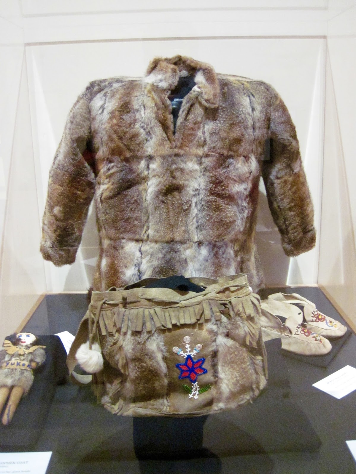
| Athabascan "gopher" fur coat, bag, doll with fine beadwork |
Along our way we spent several days in the the Kluane National Park area, and this ended up being QUITE the experience! Kluane is the largest of all Canadian National Parks and in its interior is Mt. Logan, the highest peak in Canada. It stands at 19,500 feet, which compares to Mt McKinley—the highest peak in North America—at 20,300 feet. Not only that, but Mt. Logan is surrounded by six more peaks all over 16,000 feet in the St. Elias Range. Truly impressive!! Ready for some more amazing statistics? Four contiguous national and provincial parks—Kluane National Park, British Columbia’s Tatshenshin-Alsek Provincial Park, and the Wrangell St. Elias and Glacier Bay National Parks of Alaska—straddle the international border here to make up the largest internationally protected natural area on earth—60,594 square miles in size! Also of note, within Kluane is the largest nonpolar icefield on earth, from which flows the largest glacier on earth, the Kaskawulsh!!! Whew! There is a truly amazing visitor’s center at Kluane Park which helped us greatly getting our heads around all this information. So also were the hikes we took and—OMG!—a flight over the icefield itself, including a landing on the Kaskawulsh Glacier! Unlike Mt. McKinley, which can be viewed from the highway and while hiking in the Denali National Park, Mt. Logan and the icefield can only be viewed from the air or after an extended backpacking trip. This was very disappointing, so eager we were to see it all! Then, driving along one day, by “coincidence”, we happened upon a listing in the Milepost for the Arctic Institute of North America Research Center. which provides a base of operations for arctic research scientists from around the world. We drove in there to see any exhibits they may have had. The staff were nice enough, but weren’t set up for tourists. We did learn, however, that as a side business, the airstrip, plane, and pilot that transport the scientists could be booked by the public for a flightseeing tour up to the icefield and Mt Logan. We talked about it that night and went back the next day to sign up! It was a couple days before weather conditions were such that we could realize our dream, but well worth waiting for!!!
 |
| Entrance Kluane National Park |
|
|
| Bernie stands at large relief map of Kluane Park icefield and mountains in museum |
 |
| Hiking Sheep Mountain trail at Kluane Park |
 |
| Bernie climbs aboard first |
 |
| Off we go to the icefield |
 |
| Flying over Lily on our way to the icefield and glaciers |
 |
| We fly over Slims River into Kluane |
 |
| Soon we see the foot of the glacier and icebergs in the river |
 |
| We follow the Kaskawulsh glacier up into the mountains of the icefield |
 |
| The mountains split the glaciers as they come down from the icefield, and as they come together a ridge of silt scraped off the sides of the mountains develops between them |
 |
| Another interesting phenomenon is the formation of small lakes in the glacier with water in them blue as Kool-ade |
 |
| We fly higher and higher into the mountains of the icefield... |
 |
| The snow is getting deeper and whiter beneath us... |
 |
| Until we land on the icefield itself! |
 |
| The four of us stand alone on a 3000 foot thick sheet of ice on the largest non polar icefield on earth--what a privilege! |
 |
| We thought the occasion called for making a couple snow-angels! |
 |
| After frolicking about for awhile we begin the flight back to base |
 |
| Snow turns to ice, ice turns to silted water as it flows down through the mountains... |
 |
| Forming Slims River and then filling Kluane Lake... |
 |
| The largest lake in Yukon |
I thought I might take this opportunity to answer some questions I suspect you might have about our travels in Alaska/Yukon. Here are a few I always asked recent visitors!
Q: How are the bugs?
A: There aren’t any—no kidding! Haven’t used our headnets even once, and very minimal squirts of DEET now and then. Even our battery-powered “zappers” for in-camper mosquito elimination are gathering dust and cobwebs!
Q: How much rain?
A: Minimal. Surprisingly enough, we haven’t had even a single day on which it rained for more than a few hours. This isn’t an altogether good thing, as it has been an extremely active year for forest fires in Alaska, and at one point we thought we might have to change our route because of them. So far it’s not been an issue, however, and we have a “green light” for all future travel plans at this point.
Q: What's the midnight sun like?
A: Very fun! We love that it stays quite light until after 11:00 every night because our solar collector keeps right on working, charging up our camper battery! We haven’t used our generator in weeks!! The light doesn’t seem to disturb our sleep at all either. We’re sleeping like babies. Can’t explain that except for getting lots of exercise, fresh air, and mental stimulation!
 |
| About as dark as it gets... |
Q: How bad are the roads?
A: Nooooo problem! They say the worst road conditions we are likely to have on our entire journey is the stretch we drove here on the border between Yukon and Alaska. It consisted of about 90 miles of washboardy gravel that was easy to negotiate if one simply took it slow and got out of the same track that everyone else used. A bit dusty, but we accidentally left our roof vent wide open for the whole thing and didn’t notice any appreciable dust inside the camper when it was over—thankgoodness! The Al-Can is quite the amazing road, actually! Built in just 8 months and 12 days in 1942 after the Japanese bombed Pearl Harbor, the Al-Can provided access for US military to secure the west coast from further invasions. The highway runs from Dawson Creek, British Columbia, to Delta Junction, Alaska, 1422 miles in all. The challenges of building such a road in wilderness to begin with defy the imagination, but also daunting are the ongoing challenges of maintaining it! The problem is “permafrost”, that frozen layer of earth underlying the road that continually melts under the heat of the sun, causing the road to settle and buckle in unpredictable places, then refreezes in winter, and tips this way and that in the process. The road repair projects we drove through were part of the effort to keep the highway drivable, and we are told have been going on for decades with no foreseeable end. We saw large numbers of research projects along the road testing different substrates (including styrofoam!) and venting systems, hoping to find ways to circumvent these problems.
 |
| Road construction |
 |
| Lily meets the Al-Can at Haines Junction, Yukon |
 |
| We reach the end of the Al-Can at Delta Junction, Alaska |
We also got a peek en route at the Alaskan Pipeline carrying oil from Prudhoe Bay to Valdez. Oil was discovered in Prudhoe Bay in 1969 and the pipeline built in just three years, ending in 1977. We can recall many of our high school classmates coming up to Alaska to participate in its construction back in the 1970s--a bit of an Alaskan “goldrush” for our generation! We read about all the various environmental studies done prior to building it to minimize impact on terrain and wildlife, and the ongoing safety measures to keep oil spills from happening. One has to wonder whether in the present political climate nearly so much attention would be paid to these issues. Man's dependence on fossil fuel has left many an ugly mark on our planet--that's for sure.
 |
| 800 mile long Alyeska pipeline crosses 800 miles of permafrost, rugged mountains, extensive river systems, and sensitive wildlife areas en route from Prudhoe Bay in the Arctic to Valdez in the Gulf of Alaska. |
 |
| A small section of the oil pipeline was visible as it crossed the Tanana River 548.71 miles south of the Arctic Ocean |
 |
| The 48 inch diameter pipeline carried 2 million gallons oil per day to Valdez, down these days to about 50 million gallons per day. |
 |
| At a time when minimum wage in the US was just $2.60 per hour, union pipeline workers made $11 to $18 per hour, plus overtime, and the typical workweek for them was 70-84 hours per week. |
Next stop on our journey will be Fairbanks, Alaska--so much yet to see and do and learn about!!!


So enjoying your commentary and photos! Dan, Adam, & Jack just returned from Ontario - guys fishing trip, while Lauren, I and Virginia enjoyed the fruits of Dane County. Looking forward to seeing you again - but not too soon!
ReplyDelete